Technological factors
Research Questions Technological factors
What is Location Based Service?
Location Based Services (LBS) are business and consumer services that givers users a set of services starting from the geographic location of the client. This position can be known by user entry, or a GPS receiver. These services offer the possibility to users or machines to find/locate other persons, machines, vehicles, resources and also location-sensitive services, as well as the possibility for users t track their own location. The request for location can be originated from the client himself and from other entity such as an application provider or the network. Anyway, whenever location is requested the customer has to give the permission for the location request. Most Location Based Services include two major actions:
            [1] Obtaining the location of user
            [2] Utilising this information to provide a service
Types & Groups
There are three basic types of LBS: pull, push and tracking. In the case of pull service, a customer mskes by himself a request for LBS. The push service differ from the pull services on thr point that the request for service is not technically made by the customer but by the service provider. Tracking services are the third basic type of LBS. The idea for that type of service is that someone asks for a location of the mobile terminal. All the available services until now can be divided in four major groups:
            [1] Business Applications (Asset Tracking / Field Services /
                Billing / Buying / Advertising)
            [2] Entertainment & Leisure (Gaming / Location-based Imaging /
                Athletics / Travel)
            [3] Navigation / POI Look-up / Traffic
            [4] Social Networking (Peer to Peer / Find Me / Personal Security)
Players in LBS
It is likely that many LBSs will require the involvement of many different parties in oreder to provide the complete service.

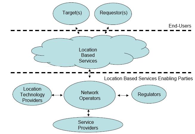
The LBS Enabling parties are described at the bottom of the picture. These players are divided roughly into four categories: Location Technology Providers (LTP), Network Operators (NO), Regulators (REG) and Service Providers (SP).
LTP are manufacturers of different hardware and software which enables positioning of mobile terminals.
NO are companies that have infrastructure for GSM telecommunications.
REG in general enables LBS through investing in sattelite technologies (e.g US government's GPS and EU's Galileo) and also by setting up laws and regulations which give guidelines how LBS can be legally implemented.
SPs are the companies that implement service logic and user interfaces, interfaces between LSB and NO systems.
The key to LBS success
The Key success of LBS depends on three main issues:
    1. The performance of location system

    2. The value of service being provided

    3. the usability of the service by the end user.
These issues can not be seen as mutually exclusive. The two critical factors that define a system’s performance are: accuracy and consistency. Accuracy, the more obvious of the two, refers to the radius in which a location technology can pinpoint the location of a cellular phone or device. Of equal importance to accuracy is consistency. Consistency is a function of two primary factors: coverage and yield. Coverage applies to the area in which location service is available, and yield refers to the location technology’s ability to obtain a location fix.
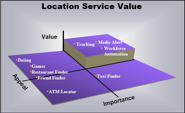
Value can be described as the ability of a service or application to bring the qualities people are looking for, which can be represented by enabling features
and impact on lifestyle and or productivity. The level to which an application or service can provide these, determines its value and relative worth in the
marketplace. The higher the value base, the higher its perceived value and the
more someone would be willing to pay for it. The current state of the most valuable services are shown in the figure.

The last factor is the usability of a service or application. Usability is a function of the end-user experience. Factors that negatively affect the end-user’s experience may eventually lead to lackluster success figures. This is exemplified with some of the location-based services that have already been enabled. Many services that rely on Cell-ID technology require the user to enter additional information about location, such as the nearest cross street, before any quality information can be displayed. This is time consuming and frustrating when working with a phone’s interface. even if a service or application can provide high value information with a strong level of interest, if experience of accessing that service is unpleasant, the long-term success of that service can be questioned.
GPS substitute
Intel has started a research to examine whether WiFi can replace GPS. The main benefit of wireless networks is that they can locate someone in an urban environment. GPS often fails in downtown where tall buildings can block signals. By timing how long it takes signals to go from the satellites to a person, a handheld containing a GPS chip can determine that person's location. While GPS determines only the latitude and longitude of an individual, wireless can also determine height and thus figure out what floor of a particular building a person is on. Boston's Skyhook Wireless already offers location services through Wi-Fi in some urban areas in the United States.
A wireless system could potentially reduce the costs of implementing location-based services. Adding GPS to a phone requires that the manufacturer add a chip. In a wireless system, the calculations to convert signal relay times into geographic location will get performed on a phone's processor. However, GPS, which has been around for years, can actually pinpoint a person with more accuracy at the moment than Wi-Fi or cellular networks. "The trickiness of triangulation (with wireless) is that the data is a little bit noisy". Wireless systems also tend to work only where several antennas have been set up. To Be Continued.....
Future: Galileo + GPS
The vast majority of satellite navigation applications are currently based on GPS performances, and great technological effort is spent to integrate satellite-derived information with a number of other techniques, in order to reach better positioning precision with improved reliability.
This scenario will significantly change in the short-term future. EGNOS, the European regional augmentation of GPS, will as from 2004 start to provide its services. Four years later, the global satellite navigation system (GNSS) infrastructure will double with the advent of GALILEO. The availability of two or more constellations, more than doubling the total number of available satellites in the sky, will enhance the quality of the services, increasing the number of potential users and applications.
GALILEO specific characteristics will bring themselves significant enhancements. Firstly, for urban areas or indoor applications, the design of the GALILEO signals will improve the availability of service (broadcast of dataless ranging channels, in addition to the classical pseudo random ranging codes). Secondly, the high-end professional market will also benefit from GALILEO signals characteristics. Three carriers phase measurements will be essential for the development of specific "TCAR" algorithms, leading to centimetre accuracy over large regions.
References
What LB technology will be accepted by large amounts of potential users? And how fast can this users adapt to this technologies?
4. What are the required infrastructure for enabling LBS?
5. What devices are currently available?
6. What future devices may be available?
7. What are the limitations of LBS?
8. What are the technical implications of LBS?
9. Are there any substitutes for this technology?
Amarantha:
1. What are the planned future developments of the infrastructure?