Difference between revisions of "GPS"
(→GPS) |
|||
| (5 intermediate revisions by the same user not shown) | |||
| Line 1: | Line 1: | ||
====GPS==== | ====GPS==== | ||
<br> | <br> | ||
The Global Positioning System (GPS) is a | The Global Positioning System (GPS) is a satellite-based navigation system made up of a network of 24 satellites placed into orbit by the U.S. Department of Defense. GPS was originally intended for military applications, but in the 1980s, the government made the system available for civilian use. GPS works in any weather conditions, anywhere in the world, 24 hours a day. | ||
<br> | |||
GPS uses these "man-made stars" as reference points to calculate positions accurate to a matter of meters. In fact, with advanced forms of GPS you can make measurements to better than a centimetre! | GPS uses these "man-made stars" as reference points to calculate positions accurate to a matter of meters. In fact, with advanced forms of GPS you can make measurements to better than a centimetre! | ||
In a sense it's like giving every square meter on the planet a unique address. | In a sense it's like giving every square meter on the planet a unique address. | ||
| Line 12: | Line 13: | ||
<br> | <br> | ||
[[Image:Triangulation.gif]] | [[Image:Triangulation.gif]] | ||
<br> | <br> | ||
<br> | <br> | ||
=====What is the signal?===== | =====What is the signal?===== | ||
<br> | <br> | ||
GPS satellites transmit two low power radio signals, designated L1 and L2. Civilian GPS uses the L1 frequency of 1575.42 MHz in the UHF band. The signals travel by line of sight, meaning they will pass through clouds, glass and plastic but will not go through most solid objects such as buildings and mountains. | GPS satellites transmit two low power radio signals, designated L1 and L2. Civilian GPS uses the L1 frequency of 1575.42 MHz in the UHF band. The signals travel by line of sight, meaning they will pass through clouds, glass and plastic but will not go through most solid objects such as buildings and mountains. | ||
<br> | <br> | ||
A GPS signal contains three different bits of information — a pseudorandom code, ephemeris data and almanac data. The pseudorandom code is simply an I.D. code that identifies which satellite is transmitting information. | A GPS signal contains three different bits of information — a pseudorandom code, ephemeris data and almanac data. The pseudorandom code is simply an I.D. code that identifies which satellite is transmitting information. | ||
<br> | |||
''Ephemeris data'' tells the GPS receiver where each GPS satellite should be at any time throughout the day. Each satellite transmits ephemeris data showing the orbital information for that satellite and for every other satellite in the system. | |||
<br> | |||
''Almanac data'', which is constantly transmitted by each satellite, contains important information about the status of the satellite (healthy or unhealthy), current date and time. This part of the signal is essential for determining a position. | |||
<br> | |||
<br> | |||
=====State-Of-The-Art===== | |||
<br> | |||
WAAS (Wide Area Augmentation System) is based on a network of approximately 25 ground reference stations that covers a very large service area. Signals from GPS satellites are received by wide area ground reference stations (WRSs). Each of these precisely surveyed | |||
reference stations receive GPS signals and determine if any errors exist. These WRSs are linked to form the U.S. WAAS network. Each WRS in the network | |||
relays the data to the wide area master station (WMS) where correction information is computed. The WMS calculates correction algorithms and assesses | |||
the integrity of the system. A correction message is prepared and uplinked to a geosynchronous satellite via a ground uplink system (GUS). The message is then broadcast from the satellite on the same frequency as GPS (L1, 1575.42MHz) to receivers or hand-held receivers) which are within the broadcast coverage area of the WAAS. These communications satellites also act as additional navigation satellites for the user, thus, providing additional navigation signals for position determination. This system is only available in North America. | |||
<br> | |||
<br> | |||
[[Image:WAASaccuracy2.gif]] | |||
<br> | <br> | ||
100 meters: Accuracy of the original GPS system, which was subject to accuracy degradation under the government-imposed Selective Availability (SA) program. | |||
<br> | |||
15 meters: Typical GPS position accuracy without SA. | |||
<br> | <br> | ||
3-5 meters: Typical differential GPS (DGPS) position accuracy. | |||
<br> | |||
< 3 meters: Typical WAAS position accuracy. | |||
<br> | <br> | ||
<br> | <br> | ||
=====Sources of GPS signal errors===== | =====Sources of GPS signal errors===== | ||
<br> | <br> | ||
| Line 42: | Line 62: | ||
<br> | <br> | ||
[7] ''Intentional degradation of the satellite signal'' — Selective Availability (SA) is an intentional degradation of the signal once imposed by the U.S. Department of Defense. SA was intended to prevent military adversaries from using the highly accurate GPS signals. The government turned off SA in May 2000, which significantly improved the accuracy of civilian GPS receivers. | [7] ''Intentional degradation of the satellite signal'' — Selective Availability (SA) is an intentional degradation of the signal once imposed by the U.S. Department of Defense. SA was intended to prevent military adversaries from using the highly accurate GPS signals. The government turned off SA in May 2000, which significantly improved the accuracy of civilian GPS receivers. | ||
<br> | |||
<br> | |||
Latest revision as of 18:44, 25 March 2006
GPS
The Global Positioning System (GPS) is a satellite-based navigation system made up of a network of 24 satellites placed into orbit by the U.S. Department of Defense. GPS was originally intended for military applications, but in the 1980s, the government made the system available for civilian use. GPS works in any weather conditions, anywhere in the world, 24 hours a day.
GPS uses these "man-made stars" as reference points to calculate positions accurate to a matter of meters. In fact, with advanced forms of GPS you can make measurements to better than a centimetre!
In a sense it's like giving every square meter on the planet a unique address.
GPS receivers have been miniaturized to just a few integrated circuits and so are becoming very economical. And that makes the technology accessible to virtually everyone.
How Does GPS Work?
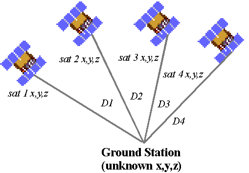
GPS satellites circle the earth twice a day in a very precise orbit and transmit signal information to earth. GPS receivers take this information and use triangulation to calculate the user's exact location. Essentially, the GPS receiver compares the time a signal was transmitted by a satellite with the time it was received. The time difference tells the GPS receiver how far away the satellite is. Now, with distance measurements from a few more satellites, the receiver can determine the user's position and display it on the unit's electronic map. A GPS receiver must be locked on to the signal of at least three satellites to calculate a 2D position (latitude and longitude) and track movement. With four or more satellites in view, the receiver can determine the user's 3D position (latitude, longitude and altitude). Once the user's position has been determined, the GPS unit can calculate other information, such as speed, bearing, track, trip distance, distance to destination, sunrise and sunset time and more.

What is the signal?
GPS satellites transmit two low power radio signals, designated L1 and L2. Civilian GPS uses the L1 frequency of 1575.42 MHz in the UHF band. The signals travel by line of sight, meaning they will pass through clouds, glass and plastic but will not go through most solid objects such as buildings and mountains.
A GPS signal contains three different bits of information — a pseudorandom code, ephemeris data and almanac data. The pseudorandom code is simply an I.D. code that identifies which satellite is transmitting information.
Ephemeris data tells the GPS receiver where each GPS satellite should be at any time throughout the day. Each satellite transmits ephemeris data showing the orbital information for that satellite and for every other satellite in the system.
Almanac data, which is constantly transmitted by each satellite, contains important information about the status of the satellite (healthy or unhealthy), current date and time. This part of the signal is essential for determining a position.
State-Of-The-Art
WAAS (Wide Area Augmentation System) is based on a network of approximately 25 ground reference stations that covers a very large service area. Signals from GPS satellites are received by wide area ground reference stations (WRSs). Each of these precisely surveyed
reference stations receive GPS signals and determine if any errors exist. These WRSs are linked to form the U.S. WAAS network. Each WRS in the network
relays the data to the wide area master station (WMS) where correction information is computed. The WMS calculates correction algorithms and assesses
the integrity of the system. A correction message is prepared and uplinked to a geosynchronous satellite via a ground uplink system (GUS). The message is then broadcast from the satellite on the same frequency as GPS (L1, 1575.42MHz) to receivers or hand-held receivers) which are within the broadcast coverage area of the WAAS. These communications satellites also act as additional navigation satellites for the user, thus, providing additional navigation signals for position determination. This system is only available in North America.

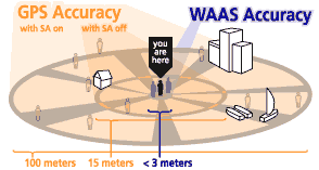
100 meters: Accuracy of the original GPS system, which was subject to accuracy degradation under the government-imposed Selective Availability (SA) program.
15 meters: Typical GPS position accuracy without SA.
3-5 meters: Typical differential GPS (DGPS) position accuracy.
< 3 meters: Typical WAAS position accuracy.
Sources of GPS signal errors
[1] Ionosphere and troposphere delays — The satellite signal slows as it passes through the atmosphere. The GPS system uses a built-in model that calculates an average amount of delay to partially correct for this type of error.
[2] Signal multipath — This occurs when the GPS signal is reflected off objects such as tall buildings or large rock surfaces before it reaches the receiver. This increases the travel time of the signal, thereby causing errors.
[3] Receiver clock errors — A receiver's built-in clock is not as accurate as the atomic clocks onboard the GPS satellites. Therefore, it may have very slight timing errors.
[4] Orbital errors — Also known as ephemeris errors, these are inaccuracies of the satellite's reported location.
[5] Number of satellites visible — The more satellites a GPS receiver can "see," the better the accuracy. Buildings, terrain, electronic interference, or sometimes even dense foliage can block signal reception, causing position errors or possibly no position reading at all. GPS units typically will not work indoors, underwater or underground.
[6] Satellite geometry/shading — This refers to the relative position of the satellites at any given time. Ideal satellite geometry exists when the satellites are located at wide angles relative to each other. Poor geometry results when the satellites are located in a line or in a tight grouping.
[7] Intentional degradation of the satellite signal — Selective Availability (SA) is an intentional degradation of the signal once imposed by the U.S. Department of Defense. SA was intended to prevent military adversaries from using the highly accurate GPS signals. The government turned off SA in May 2000, which significantly improved the accuracy of civilian GPS receivers.